Kaziranga Accident Aftermath: Assam’s 12-Point Road Safety Action Plan
Source: The Assam Tribune
Syllabus: GS Paper II – Government policies and interventions; role of the judiciary | GS Paper III – Infrastructure (roads), Disaster management, Conservation
Why in News?
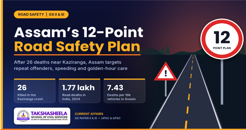
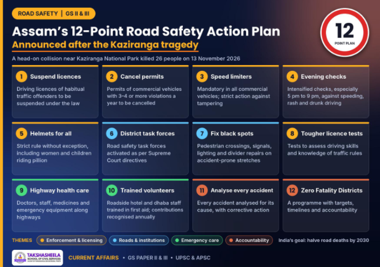
After a head-on collision near Kaziranga National Park killed 26 people on 13 November 2026, Chief Minister Himanta Biswa Sarma chaired a review with Traffic, Transport, Excise, PWD and National Highways officials and announced a 12-point road safety action plan.
The 12-Point Road Safety Action Plan
Road Safety in India: The Scale of the Problem
Indicator | Figure |
|---|---|
Road accidents, 2024 (MoRTH) | 4,87,707 |
Deaths, 2024 (MoRTH) | 1,77,175 – about 485 deaths a day |
Who dies | People aged 18–45 account for about two-thirds of deaths; road injuries are the leading cause of death for those aged 5–29 (WHO) |
Global share | About 11% of world road deaths with about 1% of the world’s vehicles |
Economic cost | Estimated at about 3% of GDP a year (MoRTH) |
Road Safety in Assam
Northeast hotspot: Assam records the most road accidents in the Northeast: 7,421 accidents and 3,296 deaths in 2023 as per MoRTH.
High lethality: Assam’s fatality rate of 7.43 deaths per 10,000 vehicles in 2024 was well above the national average of 4.58 – the fifth highest in India.
Legal and Institutional Framework
1. Motor Vehicles Act, 1988 (amended in 2019)
Steeper penalties for over-speeding, drunk driving and riding without a helmet.
Good Samaritan protection: Section 134A protects those who help accident victims from harassment.
Golden hour: Section 162 provides for cashless treatment during the golden hour.
District Road Safety Committee: Required under Section 215(3); the National Road Safety Board is provided under Section 215B.
2. Supreme Court Directions
In S. Rajaseekaran v. Union of India, the Court set up a Committee on Road Safety on 22 April 2014 under Justice K.S. Radhakrishnan.
On 30 November 2017, it directed all States to frame a road safety policy, set up a State Road Safety Council, a lead agency, a Road Safety Fund and District Road Safety Committees, and prepare Road Safety Action Plans.
3. Schemes and Initiatives
PM RAHAT (2026): The Cashless Treatment of Road Accident Victims Scheme was relaunched as PM RAHAT: cashless treatment up to Rs 1.5 lakh per victim for seven days, on any road, linked to the 112 emergency helpline.
Rah-Veer (2025): The renamed Good Samaritan scheme raised the reward for helping a victim within the golden hour from Rs 5,000 to Rs 25,000 per incident, with 10 national awards of Rs 1 lakh each every year.
Sadak Suraksha Mitra: Trains youth volunteers through the MY Bharat platform to study accident spots and advise District Road Safety Committees.
National Road Safety Policy (2010): Based on the Sundar Committee (2007), it set out the 4Es approach – Education, Enforcement, Engineering and Emergency care.
4. Global Commitments
Stockholm Declaration (2020): India is a signatory; it targets a 50% cut in road deaths by 2030.
UN Decade of Action for Road Safety, 2021–2030: Promotes the Safe System approach.
SDG 3.6: Halve global deaths and injuries from road traffic accidents.
Significance of the Action Plan
Targets repeat offenders: A small group of habitual violators causes many crashes; licence suspension and permit cancellation hit them directly.
Technology over discretion: Mandatory speed limiters reduce dependence on roadside checks.
Covers emergency care: Highway health facilities and trained dhaba staff strengthen the golden hour response, alongside PM RAHAT.
Evidence-based: Analysing every accident and fixing black spots shifts the focus from blaming drivers to fixing systems.
Accountability: The Zero Fatality District Programme and the DTO’s suspension signal that officials, too, will be answerable.
Community role: Recognising volunteers builds a culture of helping victims rather than avoiding them, in line with the Centre’s Rah-Veer and Sadak Suraksha Mitra schemes.
Challenges
Reactive policymaking: Similar drives followed earlier tragedies; the plan must not fade once public attention moves on.
Enforcement capacity: Limited traffic police, interceptors and cameras on long rural highways make round-the-clock checks difficult.
Weak trauma care: Victims were referred to Jorhat, over an hour away; rural hospitals lack trauma specialists, blood banks and ICU beds.
Institutional coordination: Transport, police, PWD, NHAI/NHIDCL, health and forest departments work in silos.
Way Forward
Tech-enabled enforcement: Use the central grant for Rule 167A cameras, number-plate recognition and e-challans, linked to licences and permits so that repeat offences are flagged automatically.
Digital tracking of speed limiters: Link speed limiters with the mandatory vehicle tracking devices and the State monitoring centre, so that overspeeding and tampering trigger alerts.
Trauma care network: A trauma centre in every district and ambulances at fixed intervals on highways, with full use of PM RAHAT.
Road safety education: Include road safety in school curricula and community campaigns.
Conclusion
Road safety must move from reactive enforcement to a culture of prevention. By institutionalising accountability, safer infrastructure and timely emergency care, Assam can turn the Kaziranga tragedy into a lasting turning point and contribute to India’s vision of halving road fatalities by 2030.
Bronze Dancing Girl
Source: The Hindu
Syllabus: GS Paper I – Indian culture: art forms, sculpture and architecture; Harappan civilisation
Why in News?
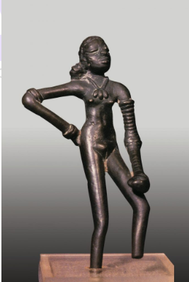
The Dancing Girl, Nizam’s jewels, Taxila jewellery, Gandhara collection and miniature paintings will move to the first gallery – “Adornments” – of the Yuge Yugeen Bharat Museum in New Delhi.
About the Bronze Dancing Girl
The Dancing Girl is the best-known work of art of the Indus Valley Civilisation and one of the earliest known bronze sculptures in the world.
Feature | Details |
|---|---|
Find spot | Mohenjo-daro, Larkana district, Sindh (now in Pakistan) |
Material and size | Bronze; about 10.5 cm tall |
Technique | Lost-wax (cire perdue) casting – a wax model coated in clay, the wax melted out and molten metal poured in |
Significance
Metallurgy: Shows that Harappans had mastered alloying and lost-wax casting – a technique still used in Dhokra craft of Bastar, Odisha and West Bengal.
Art: Reveals naturalism, movement and a sense of individual personality rare in Bronze Age art.
Society: Suggests the importance of adornment, possibly dance or performance, and the role of women in Harappan life.
Heritage and identity: A symbol of India’s civilisational antiquity; Pakistan has at times sought its return, as it was excavated in present-day Sindh.
Indus Valley Civilisation: An Overview
The Indus Valley (Harappan) Civilisation was the largest of the world’s earliest urban civilisations, contemporary with Mesopotamia and Egypt.
Aspect | Details |
|---|---|
Period | Bronze Age, about 3300–1300 BCE; Mature phase c. 2600–1900 BCE |
Discovery | Harappa by Daya Ram Sahni (1921) and Mohenjo-daro by R.D. Banerji (1922); announced to the world by John Marshall in 1924 |
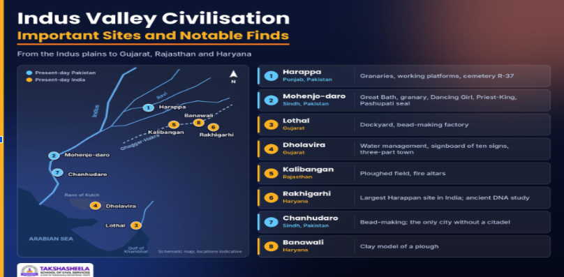
Extent | Pakistan, north-western India and parts of Afghanistan; from Manda (Jammu) in the north to Daimabad (Maharashtra) in the south, and from Sutkagen Dor (Balochistan) in the west to Alamgirpur (Uttar Pradesh) in the east |
UNESCO sites | Mohenjo-daro (Pakistan, 1980) and Dholavira (India, 2021) |
Key Features
Town planning: Grid-pattern streets, a raised citadel and lower town, standard burnt bricks (ratio 1:2:4) and covered drains.
Public structures: The Great Bath and granary at Mohenjo-daro, the dockyard at Lothal and water reservoirs at Dholavira.
Economy: Farming of wheat, barley and the earliest known cotton; standardised weights; crafts such as beads, pottery and metalwork.
Trade: Overland and sea trade with Mesopotamia, where the region was known as “Meluhha”.
Script and seals: Steatite seals with animals such as the unicorn; the script, of about 400 signs, is still undeciphered.
Religion: Terracotta mother goddess figures, the “Pashupati” seal, fire altars at Kalibangan and Lothal, and tree and animal worship.
Art: Bronze Dancing Girl, the steatite “Priest-King”, terracotta figurines and painted red-and-black pottery.
Important Sites
Prelims PYQs
Q1. [UPSC CSE 2021] Which one of the following ancient towns is well known for its elaborate system of water harvesting and management by building a series of dams and channelizing water into connected reservoirs?
(a) Dholavira
(b) Kalibangan
(c) Rakhigarhi
(d) Ropar
Answer: (a)
Q2. [UPSC CSE 2017] With reference to the difference between the culture of Rigvedic Aryans and Indus Valley people, which of the following statements is/are correct?
Rigvedic Aryans used the coat of mail and helmet in warfare whereas the people of Indus Valley Civilization did not leave any evidence of using them.
Rigvedic Aryans knew gold, silver and copper whereas Indus Valley people knew only copper and iron.
Rigvedic Aryans had domesticated the horse whereas there is no evidence of Indus Valley people having been aware of this animal.
Select the correct answer using the code given below:
(a) 1 only
(b) 2 and 3 only
(c) 1 and 3 only
(d) 1, 2 and 3
Answer: (c)
Explanation: Statement 2 is wrong: Harappans knew gold and silver but not iron. UPSC’s official answer key treats statement 3 as correct; horse-like bones reported from sites such as Surkotada remain disputed.
Poverty Line in India
Source: The Hindu
Syllabus: GS Paper I – Poverty and developmental issues | GS Paper II – Issues relating to poverty and hunger; welfare schemes for vulnerable sections | GS Paper III – Indian economy: inclusive growth, government budgeting and statistics
Why in News?
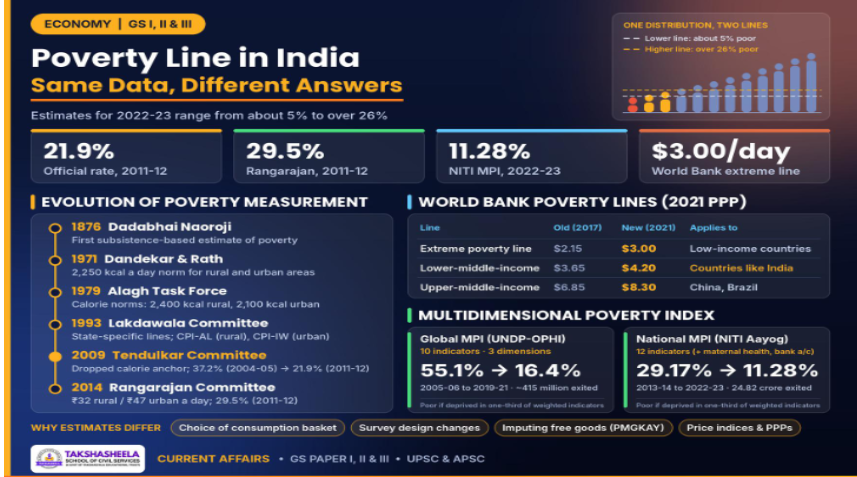
A recent article highlights the lack of an updated official poverty line in India, as poverty estimates for 2022–23 vary significantly (approximately 5% to over 26%) depending on the methodology and poverty threshold adopted.
About Poverty Lines: Key Concepts
What is a Poverty Line?
A poverty line is the minimum level of expenditure (or income) needed to meet basic, socially acceptable needs. The share of the population living below it is the headcount ratio. India estimates poverty from consumption expenditure rather than income because earnings are irregular and seasonal, particularly among informal workers and farmers.
Concept | Meaning |
|---|---|
Absolute poverty | Inability to afford a fixed basket of essentials (India’s official approach) |
Relative poverty | Deprivation relative to others, e.g. below 50-60% of median income (used in OECD countries) |
Poverty Line Basket (PLB) | The bundle of food and non-food items whose cost defines the line |
MPCE | Monthly Per Capita Consumption Expenditure, collected by the NSO through the Household Consumption Expenditure Survey (HCES) |
Evolution of Poverty Measurement in India
Committee / Body | Year | Key features | Result |
|---|---|---|---|
Dadabhai Naoroji | 1876 (later compiled in Poverty and Un-British Rule in India, 1901) | First estimate of a “subsistence” line based on a minimum diet | – |
Dandekar & Rath | 1971 | 2,250 calories per day as the norm for both areas | About 40% rural, 50% urban poor (1960-61) |
Alagh Task Force | 1979 | Calorie norms: 2,400 kcal rural, 2,100 kcal urban | Lines based on 1973-74 consumption |
Lakdawala Committee | 1993 | State-specific lines; updated with CPI-AL (rural) and CPI-IW (urban) | Retained calorie anchor |
Tendulkar Committee | 2009 | Dropped calorie anchoring; one all-India urban basket as reference for both areas; MRP data; health and education spending included | 37.2% (2004-05) → 21.9% (2011-12) |
Rangarajan Committee | 2014 | Reverted to separate rural and urban baskets; normative calorie, protein and fat needs plus non-food essentials; ₹32 rural / ₹47 urban per day | 29.5% (2011-12) |
The Multidimensional Poverty Index (MPI)
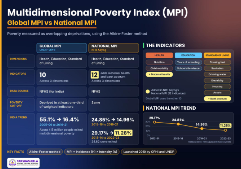
The MPI measures poverty as overlapping deprivations rather than lack of money. It was launched in 2010 by the Oxford Poverty and Human Development Initiative (OPHI) and UNDP’s Human Development Report Office, using the Alkire-Foster method.
Why Do the Estimates Differ So Much?
Choice of basket: The Tendulkar basket reflects 2004-05 consumption; rebuilding the basket on current spending patterns (mobile phones, transport, private schooling, health care) raises the line sharply.
Survey design changes: HCES 2022-23 used multiple visits and separate questionnaires for food, consumables and durables.
Imputation of free goods: Free foodgrains (PMGKAY), school meals and other transfers raise measured consumption when valued (rural MPCE rises from ₹4,122 to ₹4,247 with imputation in 2023-24).
Price indices and PPPs: The switch from 2017 to 2021 PPPs changed international estimates; State price differences change sub-national ones.
Significance of a Poverty Line
Targeting welfare: Determines eligibility and coverage for food security, housing, health insurance and cash transfers.
Fiscal planning: Guides allocation of resources between States and sectors; poverty shares have historically shaped central transfers.
Measuring progress: Provides a benchmark for SDG 1 (No Poverty), including target 1.2 of halving poverty by national definitions.
Federal equity: State-specific lines reflect price and consumption differences, e.g. between Kerala and Bihar or between the plains and the hills.
Conclusion
India needs to move beyond fragmented poverty estimates towards a credible, regularly updated and comprehensive poverty measurement framework. A robust poverty line, complemented by multidimensional indicators, can ensure evidence-based welfare targeting, equitable resource allocation and effective monitoring of SDG 1.
Previous Year Questions
Q1. [UPSC CSE Prelims 2026] Consider the following statements about Multidimensional Poverty Index (MPI):
MPI is calculated using Alkire-Foster methodology.
MPI calculated by NITI Aayog has a total of twelve indicators.
Maternal Health and Bank Account are common indicators in the MPI of NITI Aayog and MPI of United Nations Development Programme (UNDP).
(a) 1 and 2 only
(b) 1, 2 and 3
(c) 1 and 3 only
(d) 2 only
Answer: (a)
Explanation: Both the global and national MPI use the Alkire-Foster method. NITI Aayog’s MPI has 12 indicators. Maternal health and bank account are the two India-specific additions and are not part of the 10-indicator global MPI, so statement 3 is wrong.
Q2. [APSC CCE Prelims 2025] As per NITI Aayog’s multidimensional poverty estimates for 2022-23, the percentage of population in Assam classified as poor is:
(A) 36.97%
(B) 26.37%
(C) 14.47%
(D) 13.73%
Answer: (C)
Explanation: Assam’s multidimensional poverty headcount fell from 36.97% in 2013-14 to 14.47% in 2022-23. Note that 36.97% is the 2013-14 figure, a deliberate distractor.
Cyclone Akvan
Source: The Hindu
Syllabus: GS Paper I – Important geophysical phenomena such as cyclones; changes in critical geographical features | GS Paper III – Disaster and disaster management; crop insurance; climate change
Why in News?
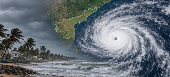
The deep depression over the Bay of Bengal intensified into Cyclone Akvan on 16 November 2026 and is likely to become a severe cyclonic storm, crossing the Andhra Pradesh coast as a very severe cyclonic storm with winds gusting to 145 kmph.
It is the third cyclone to threaten Andhra Pradesh in about three weeks, after Arnab (28 October) and Murasu (3 November).
About Tropical Cyclones
A tropical cyclone is an intense low-pressure system that forms over warm tropical seas, with winds spiralling inwards anticlockwise in the Northern Hemisphere and clockwise in the Southern Hemisphere. They are called hurricanes in the Atlantic and eastern Pacific, typhoons in the western Pacific and willy-willies in north-west Australia.
Conditions for Formation
Warm sea surface: Sea surface temperature above about 26.5-27°C extending to a depth of about 50 m.
Coriolis force: Enough to cause rotation; hence cyclones rarely form within about 5° of the equator.
Low vertical wind shear: Small change in wind speed and direction with height, so the storm column stays intact.
Pre-existing disturbance: A low-pressure area or cyclonic circulation, often linked to the ITCZ.
Upper-level divergence and humid mid-troposphere: To sustain rising air and convection.
Structure
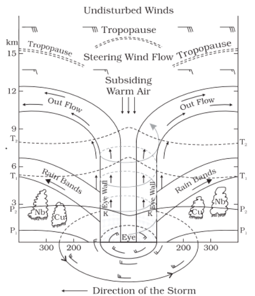
Eye: A calm, often cloud-free centre of sinking air and lowest pressure.
Eyewall: A ring of towering cumulonimbus clouds with the strongest winds and heaviest rain.
Spiral rain bands: Bands of cloud and rain extending hundreds of km from the centre.
IMD Classification of Cyclonic Disturbances
Tropical vs Temperate (Extratropical) Cyclones
Feature | Tropical cyclone | Temperate cyclone |
|---|---|---|
Region | Between about 5° and 30° latitude | Mid-latitudes, about 35°-65° |
Origin | Over warm seas only | Over both land and sea |
Energy source | Latent heat of condensation | Contrast between warm and cold air masses (fronts) |
Fronts | None | Warm and cold fronts present |
Size | Smaller (a few hundred km) but more intense | Larger (up to thousands of km) |
Movement | East to west (with trade winds) | West to east (with westerlies) |
Life span | About a week; dies over land | Can last longer and cross continents |
Indian example | Akvan, Amphan, Fani | Western disturbances bringing winter rain and snow to north India |
How Cyclones Are Named
Who names: The Regional Specialised Meteorological Centre (RSMC), New Delhi, run by IMD, names cyclones over the Bay of Bengal and Arabian Sea once they reach cyclonic-storm strength. It is one of six RSMCs worldwide.
Panel: WMO/ESCAP Panel on Tropical Cyclones. Naming began in September 2004 with eight members; five more (Iran, Qatar, Saudi Arabia, UAE and Yemen) joined in 2018, making 13 members.
2020 list: 169 names (13 from each member), used sequentially, column-wise. Members are listed alphabetically.
Conclusion
As cyclones continue to pose recurring threats to coastal regions, strengthening early-warning systems, resilient infrastructure and community preparedness is crucial. Integrating scientific forecasting with ecosystem-based solutions and effective disaster management can minimise vulnerabilities and enhance India’s long-term coastal resilience.
Previous Year Questions
Prelims
Q1. [UPSC CSE Prelims 2020] Consider the following statements:
Jet streams occur in the Northern Hemisphere only.
Only some cyclones develop an eye.
The temperature inside the eye of a cyclone is nearly 10°C lesser than that of the surroundings.
(a) 1 only
(b) 2 and 3 only
(c) 2 only
(d) 1 and 3 only
Answer: (c)
Explanation: Jet streams occur in both hemispheres. Not every cyclone develops a clear eye. The eye is warmer, not cooler, than its surroundings because of sinking, compressed air.